


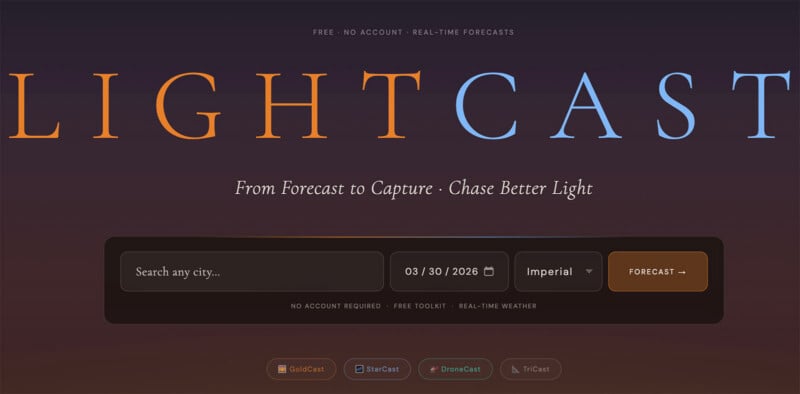
Megan Tucker, a photographer and marketing student at Bentley University, has launched LightCast Suite, a comprehensive browser-based platform designed to solve one of the most persistent challenges in landscape and outdoor photography: the unpredictability of light and atmospheric conditions. As digital photography continues to evolve, the demand for precise data has moved beyond simple shutter speeds and apertures into the realm of complex meteorology. Tucker’s suite of tools aims to bridge the gap between raw weather data and actionable photographic insight, providing creators with a sophisticated scoring system that determines whether a trek to a remote location will result in "epic" light or a wasted journey.

The platform emerges at a time when photographers are increasingly reliant on digital planning tools to maximize their efficiency and success rates. For many professionals and serious hobbyists, the "chase"—the pursuit of the perfect sunrise or a clear Milky Way—often involves significant travel, expense, and time. By synthesizing multiple atmospheric variables into a simplified 0-100 scale, LightCast Suite offers a streamlined alternative to the dense, often confusing data provided by standard meteorological applications.
The Genesis of LightCast: From Personal Frustration to Public Solution
The development of LightCast Suite follows a classic trajectory of innovation born from personal necessity. Megan Tucker, a member of the Bentley University class of 2026, found herself frequently grappling with the limitations of standard weather apps. While traditional forecasts provide temperature, precipitation, and general cloud cover, they rarely account for the specific nuances that create high-quality photographic light, such as the altitude of cloud layers or the precise visibility required for deep-sky astrophotography.

Tucker’s background as a drone photographer and marketing student provided a unique intersection of technical need and user-centric design philosophy. Her portfolio, which features striking aerial perspectives and vibrant landscapes, serves as the proof of concept for the data-driven approach she has now codified into her software. The suite was built to address the specific "pain points" of the photographic community, particularly the discouragement of driving long distances only to find a "flat" sky or atmospheric haze that ruins a planned shot.
In an industry where many specialized tools are hidden behind subscription paywalls or complex mobile interfaces, Tucker opted for a browser-based, free-to-use model. This decision reflects a growing movement within the creative community toward accessible, open-access tools that prioritize utility over monetization.
Technical Architecture and the GoldCast System
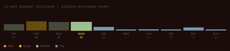
At the heart of LightCast Suite is "GoldCast," a tool specifically engineered to predict the quality of light during the golden hour—the period shortly after sunrise or before sunset when the sun is low in the sky, producing soft, warm tones. Unlike a standard "partly cloudy" forecast, GoldCast analyzes a hierarchy of atmospheric conditions to generate its 0-100 score.
The algorithm considers several critical factors:
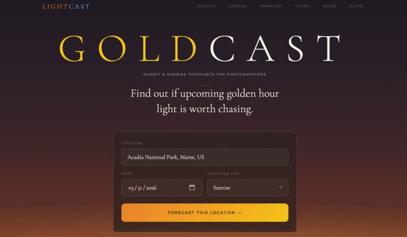
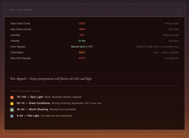
- Cloud Cover and Altitude: The most significant factor in a dramatic sunset is not just the presence of clouds, but their height. High-level clouds (cirrus) are essential for catching the sun’s rays from below the horizon, creating the vibrant reds and oranges associated with "epic" light. Low-level clouds, conversely, can block the sun entirely, leading to "flat" or dull conditions.
- Humidity and Visibility: High humidity often leads to atmospheric haze, which can scatter light in a way that reduces contrast and clarity. GoldCast monitors these levels to ensure the atmosphere is "clean" enough for crisp captures.
- Precipitation: Even light rain can drastically alter the refractive index of the air, often flattening color spreads.
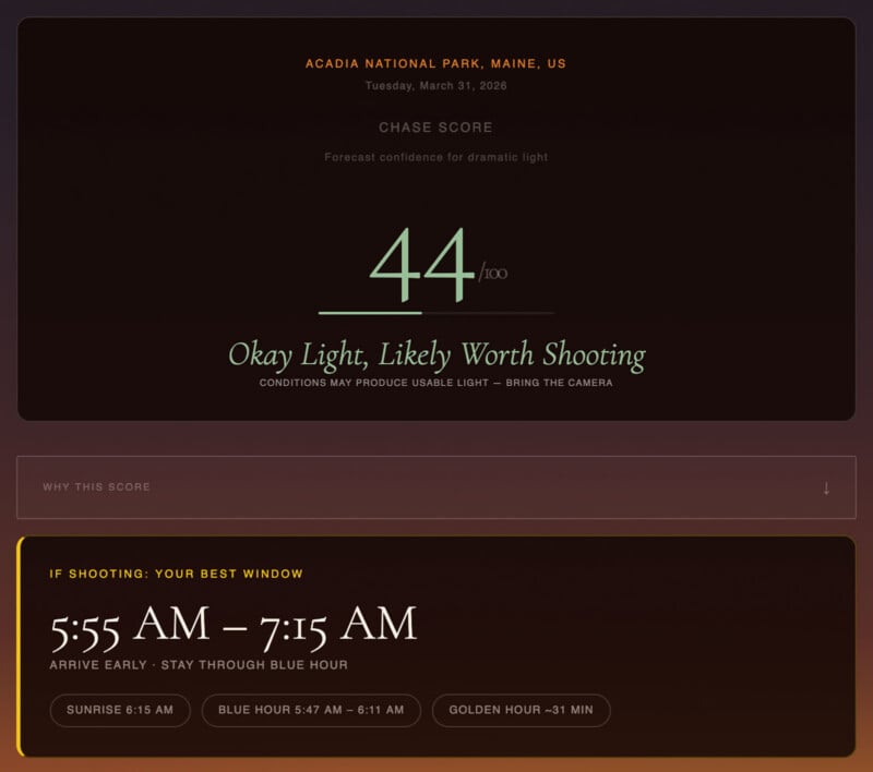
The results are categorized into four distinct tiers. A score of 0-34 indicates "Flat Light," suggesting a low probability of color. Scores from 35-54 are deemed "Worth Shooting," representing average but workable conditions. The "Great Conditions" tier (55-74) signals a high likelihood of a beautiful sky, while the "Epic Light" tier (75-100) identifies those rare moments when all atmospheric variables align for a portfolio-grade event.
Navigating the Night: The StarCast Module
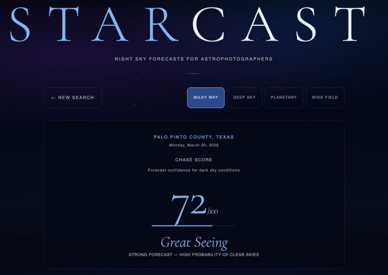
For astrophotographers, the requirements for a successful shoot are even more stringent than those for landscape photographers. LightCast Suite addresses this through the "StarCast" module, which focuses on the celestial and atmospheric variables necessary for night sky photography.
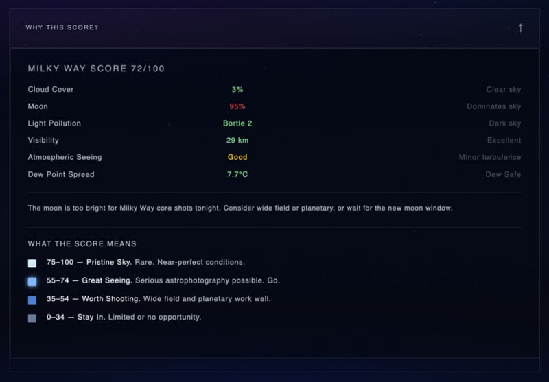
Astro-imaging requires more than just a lack of rain; it demands "pristine" skies. StarCast calculates its scores based on:
- Moon Phase and Position: The brightness of the moon can easily wash out the faint light of the Milky Way or distant nebulae. StarCast provides moonrise and moonset times to help photographers find windows of true darkness.
- Atmospheric Seeing: This refers to the stability of the air. Turbulent air causes stars to "twinkle" or appear blurry in long exposures. StarCast evaluates atmospheric stability to advise on the potential for sharp, detailed shots.
- Dew-Point Spread: This is a critical factor for equipment safety and image quality. When the temperature drops to the dew point, moisture can condense on camera lenses, ruining long-exposure sequences.
- Light Pollution: By integrating location-based light pollution data, the tool helps users understand the "Bortle scale" of their chosen spot, indicating how much of the night sky will be visible to the naked eye and the sensor.
StarCast also provides a roadmap of the night sky, identifying visible planets, major constellations, and the position of the Milky Way core. This level of integration allows photographers to plan their compositions well before they arrive on-site.
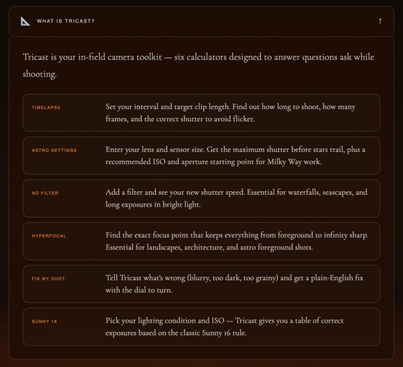
Tricast: The Integrated In-Field Toolkit
Recognizing that data is only half the battle, Tucker included "Tricast," a suite of six calculators designed for use while the photographer is actively shooting. This toolkit eliminates the need for multiple disparate apps, centralizing the technical math required for advanced techniques.
The Tricast module includes:
- ND Filter Calculator: Neutral Density filters allow for long exposures in bright light, but calculating the resulting shutter speed can be cumbersome. This tool allows photographers to input their base exposure and filter strength to get an instant result.
- Hyperfocal Distance Calculator: For landscape photographers wanting "front-to-back" sharpness, calculating the hyperfocal distance is essential. This tool helps determine the exact point of focus to maximize depth of field.
- Timelapse Calculator: This helps users determine how many frames they need and what the interval should be to achieve a specific duration of finished video.
- Astro Settings: A specialized calculator for determining the maximum exposure time before star trailing occurs (based on the "Rule of 500" or NPF rule).
- Sunny 16 and "Fix My Shot": These provide foundational exposure guidance and troubleshooting tips for common errors like overexposure or motion blur.
Industry Context and Comparative Analysis
The launch of LightCast Suite enters a competitive market currently dominated by established apps like PhotoPills, The Photographer’s Ephemeris (TPE), and Clear Outside. However, LightCast distinguishes itself through its specific focus on "scoring" rather than just "mapping." While PhotoPills is widely regarded as the "Swiss Army Knife" of photography planning for its augmented reality and mapping features, it often presents a steep learning curve for beginners.
LightCast Suite’s 0-100 scoring system provides a more intuitive "Go/No-Go" signal that appeals to photographers who may not want to interpret raw meteorological graphs themselves. Furthermore, by being a web-based application, it circumvents the friction of app store downloads and updates, making it accessible on any device with an internet connection—from a high-end desktop during the planning phase to a smartphone in the field.
Implications for the Photographic Community
The broader implications of tools like LightCast Suite extend into environmental and economic considerations. As fuel costs rise and the environmental impact of travel becomes a more prominent concern, "precision photography"—the act of only traveling when conditions are optimal—becomes a more sustainable practice. By reducing the number of "failed" trips, photographers can lower their carbon footprint and maximize their creative output.
Moreover, the democratization of this data empowers a new generation of photographers. By providing professional-grade forecasting for free, Tucker is lowering the barrier to entry for high-end landscape and astrophotography. This transparency in data helps level the playing field between seasoned professionals who have "learned the weather" through decades of experience and newcomers who are still developing their instincts.
Future Outlook
While LightCast Suite is currently a fully functional browser tool, its development reflects the ongoing trend of "smart" photography. As API (Application Programming Interface) technology becomes more robust, the potential for integrating real-time satellite imagery and AI-driven predictive modeling into the suite is significant.
For now, Megan Tucker’s creation stands as a testament to the power of student-led innovation. By combining a passion for the visual arts with a data-driven marketing mindset, she has provided the global photography community with a powerful, accessible, and highly practical resource. As the platform gains users, the feedback loop from the community will likely drive further refinements, ensuring that LightCast remains a vital part of the modern photographer’s digital kit.
LightCast Suite is currently available to the public without the need for registration, offering a transparent and efficient way for photographers to "chase the light" with confidence and precision.
