


The legal battle over the intersection of national security and the First Amendment has reached a new flashpoint as a Minnesota-based photojournalist files a federal lawsuit against the Federal Aviation Administration (FAA). The litigation targets a sweeping and controversial Temporary Flight Restriction (TFR) that effectively bans the operation of Unmanned Aircraft Systems (UAS), or drones, within a significant radius of Department of Homeland Security (DHS) assets. This legal challenge, spearheaded by veteran photographer Rob Levine, argues that the current federal mandate creates an "invisible and moving" no-fly zone that is impossible for journalists to navigate, thereby stifling the public’s right to observe government operations.
The restriction at the heart of the dispute was enacted on January 16, 2026, and is slated to remain in effect until late October 2027. Under the terms of the TFR, drone pilots are prohibited from flying within 3,000 feet laterally and 1,000 feet vertically of any DHS asset. Critically, the definition of an "asset" includes not only permanent structures like federal buildings and detention centers but also mobile units, such as unmarked vehicles used by Immigration and Customs Enforcement (ICE) and Customs and Border Protection (CBP).
The Genesis of Operation Metro Surge
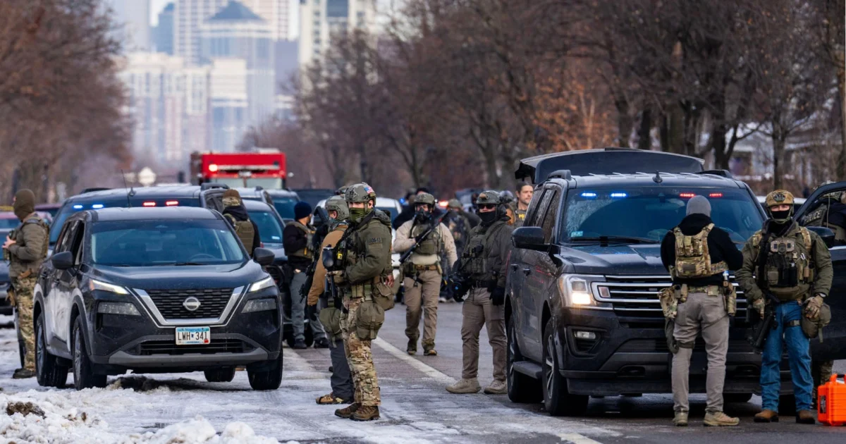
The implementation of the drone ban coincided with the launch of "Operation Metro Surge," a coordinated federal initiative led by ICE and CBP. The operation was designed to increase the apprehension and processing of undocumented immigrants within major metropolitan areas, with a specific and heavy focus on the state of Minnesota. As federal agents moved into urban centers to conduct enforcement actions, the FAA issued the TFR to secure the airspace surrounding these operations.
While the FAA frequently issues TFRs for localized events such as wildfires, major sporting events, or presidential movements, the scope of this particular order is unprecedented. It applies not only to DHS assets but also extends to those belonging to the Department of Defense (DoD) and the Department of Energy (DoE). For photojournalists like Levine, who rely on aerial perspectives to document police activity and public demonstrations, the order represents a near-total blackout of aerial transparency in urban environments.
The Legal Argument: Vagueness and Due Process
Represented by the Reporters Committee for Freedom of the Press, Levine’s lawsuit contends that the FAA’s order violates both the First and Fifth Amendments of the U.S. Constitution. The primary legal argument hinges on the concept of "vagueness." Under the Fifth Amendment’s Due Process Clause, laws and regulations must be clear enough that a reasonable person can understand what conduct is prohibited.
Grayson Clary, a staff attorney at the Reporters Committee for Freedom of the Press, argues that the TFR fails this standard because it applies to unmarked vehicles. "You have no way of knowing in advance before you fire up the drone whether you are within a prohibited distance of, say, an unmarked car that ICE is using for immigration enforcement," Clary stated. Because these vehicles are indistinguishable from civilian traffic, a drone pilot could unknowingly enter a restricted zone and face severe federal penalties, including the seizure of equipment or criminal charges.
Furthermore, the lawsuit alleges a violation of the First Amendment, asserting that the TFR functions as a prior restraint on newsgathering. Aerial photography has become a staple of modern journalism, providing essential context for large-scale enforcement actions that cannot be captured from the ground. By creating a moving perimeter around federal agents, the government is effectively insulating its actions from visual scrutiny.
A History of Aerial Advocacy
Rob Levine is no stranger to challenging federal flight restrictions. His involvement in this case follows a history of pushing for drone access in high-stakes environments. In 2016, during the Standing Rock protests in North Dakota, Levine challenged an FAA TFR that restricted drone flights over the protest sites where activists were demonstrating against the Dakota Access Pipeline.
Initially, the FAA denied his requests for access, but following a sustained legal and public push, the agency reversed its decision and granted him a three-day waiver. This made Levine the only photographer with authorized aerial access to document the standoff between law enforcement and protesters. His past experiences have informed his current apprehension regarding Operation Metro Surge. Levine expressed concerns that without judicial intervention, federal agents might use the TFR as a pretext to "manhandle" constitutional observers, destroy equipment, or arrest journalists who are simply attempting to do their jobs.

Timeline of the Dispute
The escalation of the conflict over the Minnesota airspace can be traced through a series of administrative and legal actions:
- January 8, 2026: Federal agents begin increased activity in Minneapolis and surrounding areas as part of preliminary enforcement actions.
- January 16, 2026: The FAA officially issues the TFR, establishing the 3,000-foot lateral and 1,000-foot vertical exclusion zones around DHS, DoD, and DoE assets.
- January 28, 2026: The National Press Photographers Association (NPPA) issues a formal press release condemning the order, with President Alex Garcia labeling the restriction "impossible to comply with."
- February 2026: Major news organizations, including The New York Times and The Washington Post, join the NPPA in sending a formal letter of protest to the FAA, demanding a narrowing of the TFR’s scope.
- March 16, 2026: Rob Levine officially files his lawsuit against the FAA in federal court.
- October 29, 2027: The scheduled expiration date for the current TFR, unless extended or vacated by court order.
Industry Reaction and Collective Opposition
The journalism community has rallied behind Levine’s cause, viewing the TFR as a dangerous precedent for government secrecy. The NPPA has been particularly vocal, emphasizing that the "moving" nature of the restriction creates a trap for even the most well-intentioned pilots.
"Our members are finding it impossible to comply with the order—even when photographing stories with drones that are unrelated to these agencies," said NPPA President Alex Garcia. He noted that because drones are used for a variety of tasks—ranging from real estate photography to environmental reporting—a pilot filming a park could suddenly find themselves in violation of federal law if an unmarked DHS vehicle drives by on a nearby street.
The involvement of legacy media outlets like The New York Times and The Washington Post underscores the severity of the situation. These organizations argue that the TFR does not serve a legitimate safety or security purpose that could not be achieved through less restrictive means. Instead, they suggest the order is designed to prevent the documentation of controversial immigration enforcement tactics.
Technical Limitations and the "B4UFLY" Dilemma
Modern drone pilots rely heavily on software applications like the FAA’s own "B4UFLY" or third-party services like DJI’s GeoZone system to identify restricted airspace in real-time. These systems typically pull data from the FAA’s aeronautical databases to show permanent no-fly zones (like airports) and temporary ones (like stadiums).
However, the technology is currently incapable of tracking "moving" TFRs tied to specific vehicles. Because the locations of DHS assets are not broadcast on public transponders for security reasons, there is no digital "fence" that a drone’s software can recognize. This puts the entire burden of identification on the pilot, who has no visual or digital means of identifying which SUVs or vans on a city street belong to the Department of Homeland Security.
Broader Implications for Public Accountability
The outcome of Levine v. FAA could have lasting implications for how the U.S. government regulates the use of technology in public spaces. If the court upholds the FAA’s right to issue "moving" TFRs based on the presence of federal personnel, it could lead to a broader application of these rules during civil unrest, political rallies, or other events of significant public interest.
Legal analysts suggest that the case will force the judiciary to balance the "compelling interest" of national security against the "fundamental right" of the press to document government activity. If the government cannot prove a specific, tangible threat that drones pose to these assets—beyond the mere desire for operational privacy—the TFR may be found unconstitutional.
For now, the drone community in Minnesota and across the country remains in a state of legal limbo. As Operation Metro Surge continues, the "invisible" boundaries in the sky remain a significant hurdle for those seeking to provide an aerial lens on the actions of the state. The lawsuit serves as a critical test case for whether the sky remains a public forum or a restricted domain accessible only to the government itself.