


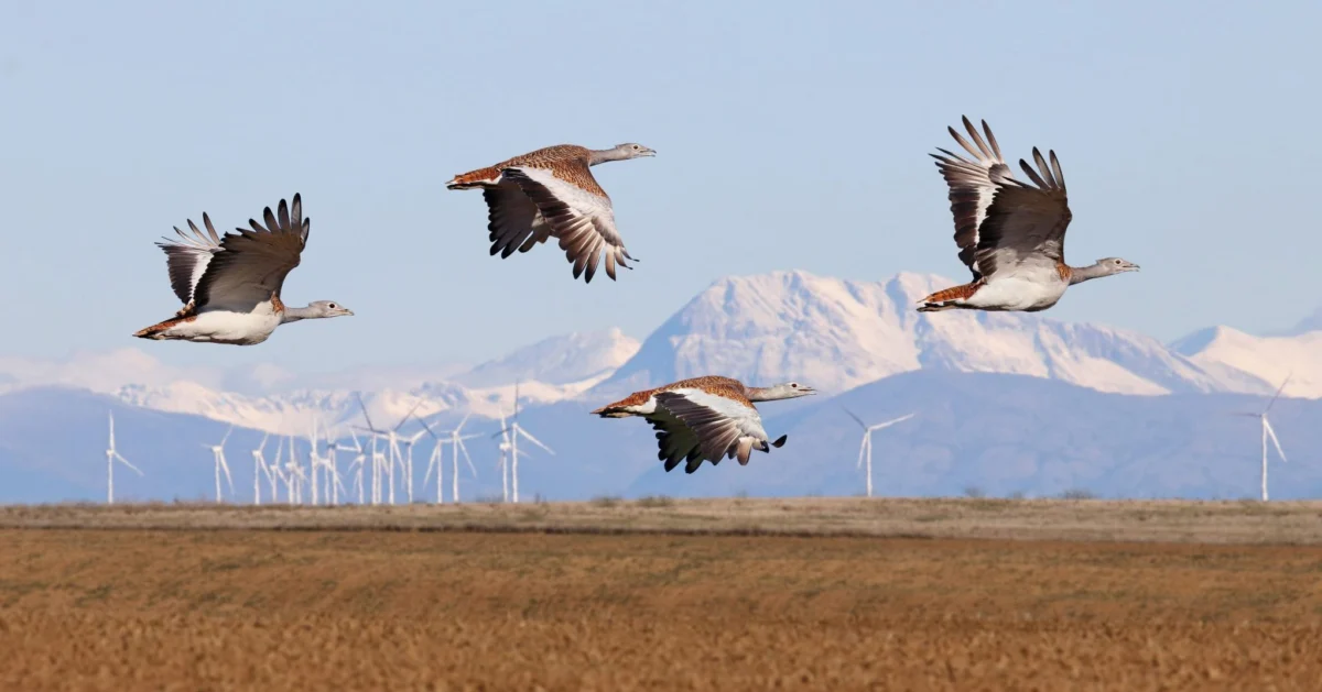
The urgent imperative to transition to renewable energy sources to avert ecological collapse is met with an equally critical need to safeguard vulnerable wildlife. This delicate balancing act is increasingly being addressed through the strategic deployment of wind and solar infrastructure, with a growing emphasis on siting these facilities in locations that minimize harm to avian populations. The most effective and economically viable approach to preventing wind turbines from endangering birds lies in meticulous site selection, prioritizing areas remote from sensitive species and major migratory routes, thereby ensuring minimal ecological impact or facilitating straightforward mitigation strategies. Sensitivity maps, sophisticated spatial tools designed to identify areas requiring avoidance, are rapidly gaining traction across the renewable energy industry and governmental bodies worldwide.
At the forefront of developing these crucial spatial tools is BirdLife International, a global partnership of conservation organizations. Historically, the Avian Sensitivity Tool for Energy Planning (AVISTEP) was a pioneering initiative of its kind, initially concentrating its efforts on ecological assessments in Africa and Asia. Building upon this foundational methodology, BirdLife’s European partners have demonstrated remarkable initiative by adapting the AVISTEP approach to incorporate localized data, thereby developing comprehensive national sensitivity maps. This localized adaptation is vital, as avian migration patterns, breeding grounds, and foraging habits are intrinsically tied to specific regional geographies and ecological conditions.
The European Union is currently engaged in a concerted effort to designate dedicated Renewable Acceleration Areas (RAAs). These RAAs are intended to streamline and expedite the development of renewable energy projects, both on land and at sea. The strategic spatial planning for these crucial areas is increasingly reliant on sensitivity maps as a scientifically robust tool. These maps provide a critical evidence base, enabling Member States to make informed decisions that strategically minimize adverse impacts on biodiversity, particularly on avian species that are often disproportionately affected by large-scale infrastructure projects.

Real-World Impact: Sensitivity Maps in Action in Spain and Portugal
The tangible benefits of utilizing sensitivity maps are vividly illustrated by the experiences of BirdLife’s partners in Spain and Portugal. In Spain, SEO/BirdLife has been a vanguard in advocating for responsible renewable energy development since the advent of wind farms in Tarifa, situated in the Strait of Gibraltar, during the 1990s. This region, a vital flyway for migratory birds, presented early challenges and opportunities for conservation efforts. Historically, SEO/BirdLife has not shied away from robust advocacy, frequently employing legal recourse against projects proposed or constructed in ecologically significant areas that posed a direct threat to sensitive species.
Through the development of comprehensive bird sensitivity maps for both onshore and offshore wind and solar photovoltaic installations, SEO/BirdLife ensures adherence to the foundational principle of the mitigation hierarchy: avoidance. By proactively identifying and flagging areas of high ecological value, these maps serve as a crucial first line of defense, preventing potential harm before it occurs. This proactive approach is a game-changer, effectively steering harmful developments away from critical habitats essential for biodiversity. The maps, publicly accessible, provide a transparent framework for developers and policymakers, fostering a more responsible approach to renewable energy expansion. For instance, a key output of SEO/BirdLife’s work is the creation of detailed online mapping tools that allow users to visualize bird sensitivity across different regions of Spain, integrating data on species distribution, migratory routes, and key breeding or roosting sites.
Across the border, Portugal’s partner, SPEA (Sociedade Portuguesa para o Estudo das Aves), has powerfully demonstrated the impact of data-driven conservation. SPEA’s offshore sensitivity maps, which meticulously analyzed the risks of collision and displacement for 34 key seabird species, proved instrumental in shaping national energy policy. The influence of SPEA’s maps was so significant that they led to a revision of an already finalized offshore wind deployment plan. The data highlighted areas of high avian sensitivity within zones initially identified by the government through its Marine Rapid Readiness Assessment (MRRA) initiative. Consequently, the Ericeira site, initially slated for development, was removed from the plan, and the Viana do Castelo area was significantly downsized to reduce potential ecological impacts. This case exemplifies the critical role sensitivity maps can play, not only in guiding the initial designation of RAAs but also in refining and correcting pre-identified areas, thereby preventing negative consequences for wildlife even after initial planning stages. The MRRA, while aiming for rapid deployment, initially lacked comprehensive biodiversity data, underscoring the necessity of integrating such information early in the planning process.
Influencing Government Decisions: Italy and Poland Embrace Sensitivity Mapping
The collaborative efforts, bolstered by funding from the European Climate Foundation (ECF), have also yielded significant results in Italy and Poland. LIPU (Lega Italiana Protezione Uccelli) in Italy and OTOP (Oftopolska Organizacja Ziemi) in Poland have both produced crucial avian sensitivity maps for onshore and offshore wind energy development.

In Italy, LIPU’s maps adopt a clear and intuitive traffic-light color-coding system. Areas designated in red signify the highest levels of avian sensitivity, mandating strict avoidance. Yellow areas indicate moderate sensitivity, requiring careful consideration and mitigation measures, while green zones represent the lowest risk, potentially suitable for development with standard environmental protocols. This visually accessible system aids local municipalities and regional administrations in making informed decisions regarding renewable energy projects. The maps are being integrated into regional planning documents, particularly in wind-rich regions like Sardinia, where the impact of wind energy on resident and migratory bird populations is a significant concern. The integration of protected areas, marked in grey, further reinforces the commitment to preserving ecologically vital zones by rendering them strictly off-limits for any construction.
Similarly, OTOP in Poland has developed sensitivity maps employing varying tones and gradations of color to denote different levels of avian sensitivity. This nuanced approach was adopted following extensive consultations with key decision-makers, underscoring the importance of a collaborative dialogue with authorities and the business sector to ensure the practical utility and effectiveness of these tools. The Polish maps also prominently feature protected areas in a distinct color, signaling their inviolable status.
A significant achievement in Poland is the recommendation for sensitivity maps to be incorporated as a mandatory requirement within government guidelines for renewable energy mapping potential. This integration is a testament to the power of sustained engagement and consultation, involving not only OTOP but also key industry stakeholders such as the Polish Wind Energy Association. This collaborative process has helped to establish a more standardized and ecologically informed approach to renewable energy planning in the country.
Sensitivity Maps Evolve into a New Standard for Biodiversity Protection
BirdLife International and its network of partners are increasingly recognized as authoritative voices in the field of sensitivity mapping. While other organizations are also developing similar tools, the BirdLife Partnership has been a pioneering force, driving the adoption of these spatial planning instruments in numerous countries. Beyond Spain, Portugal, Italy, and Poland, BirdLife partners in Bulgaria, the United Kingdom, the Czech Republic, Hungary, Ireland, Romania, Slovenia, Croatia, Finland, and Malta have actively produced and continue to develop onshore and offshore wind sensitivity maps.

As countries across the region experience an intensified drive to accelerate renewable energy deployment, there is a palpable appetite to expand the application of sensitivity maps to other nations, including Greece, Iceland, and Georgia. This growing demand reflects a global recognition of the indispensable role these maps play in reconciling energy needs with conservation imperatives.
While sensitivity maps are generally designed for ease of use, potential for misinterpretation can arise. To mitigate this, BirdLife partners have developed comprehensive recommendations and indicators for governments and industry stakeholders, providing guidance on the optimal interpretation and application of these maps. These guidelines emphasize that sensitivity maps serve as a crucial initial screening tool but should not supplant rigorous environmental assessments. Specifically, it is crucial to note that these maps should not replace Environmental Impact Assessments (EIA), Strategic Environmental Assessments (SEA), or Appropriate Assessments (AA), which provide detailed, project-specific ecological evaluations.
A Crucial Piece of a Larger Puzzle: Integrating Conservation and Renewable Energy
It is vital to understand that sensitivity maps represent just one component within a broader framework for minimizing negative impacts. They are integral to the initial phase of the mitigation hierarchy, a structured approach that prioritizes avoidance, followed by mitigation, restoration, and offsetting. For nature conservation and the expansion of renewable energy to coexist harmoniously, a science-based approach is paramount, guiding efforts to reduce adverse effects on biodiversity. Furthermore, continued innovation in renewable energy technologies, focusing on enhanced energy saving and efficiency, is equally crucial.
As the pace of renewable energy rollout accelerates, it is imperative that the correct steps and processes are diligently followed. Biodiversity and ecosystems must be afforded serious consideration, necessitating strengthened strategic investments in nature restoration and the cultivation of robust political will. Governments have a pivotal role to play in comprehending and implementing sound spatial planning principles and effective management of protected areas. This enables developers to undertake projects that are not only economically viable but also ecologically responsible. Ultimately, the protection of nature represents a win-win scenario for wildlife, society, and industry alike, providing a sustainable pathway through the challenging yet critical decades ahead. Sensitivity maps stand as a vital tool in this collective journey, contributing significantly to the protection of the birds we cherish and the ecosystems they inhabit.
