


Outdoor photography has long been a discipline defined by a precarious balance between technical skill and the whims of nature. For decades, landscape and astrophotographers have relied on a patchwork of tools to predict when the atmosphere might align to produce a portfolio-worthy shot. Matthew Raifman, a professional photographer and developer, has sought to eliminate this logistical friction with the launch of Atmos for Weather & Photo, a new iOS application designed to synthesize complex meteorological variables into actionable intelligence for photographers.
The app, commonly referred to as Atmos, represents a shift in how weather data is presented to the creative community. Rather than offering a standard forecast of temperatures and precipitation, Atmos employs a proprietary scoring model that evaluates "shootability." This metric is designed to answer the fundamental question that precedes every outdoor excursion: Is it worth the trip? By aggregating data on cloud altitude, atmospheric humidity, sun angles, and solar activity, Atmos provides a specialized lens through which photographers can view the upcoming week.
The Evolution of Photographic Planning
The genesis of Atmos lies in a common frustration shared by outdoor enthusiasts. To plan a single sunrise shoot, a photographer might typically consult a standard weather app for general conditions, a tide chart for coastal positioning, a sun-tracking app for light direction, and a specialized aviation or astronomical tool for cloud heights and visibility. This fragmented workflow often leads to "analysis paralysis" or, worse, missed opportunities due to misinterpreted data.

Raifman’s approach with Atmos was to build a centralized hub that does the heavy lifting of data interpretation. The app’s primary innovation is its ability to process raw atmospheric data into genre-specific scores. For instance, a morning that might be rated as "poor" for a traditional landscape photographer due to heavy fog might be rated as "epic" for a macro or forest photographer looking for moody, diffused light.
This level of customization acknowledges that "good weather" is a subjective term in the world of photography. By catering to 12 distinct genres—including wildlife, long exposure, Milky Way, and infrared—Atmos provides a nuanced outlook that standard meteorological services cannot match.
Meteorological Sophistication: Beyond the Standard Forecast
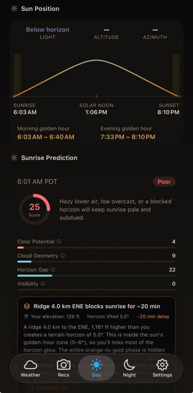
At the heart of Atmos is a sophisticated analysis of cloud layers and atmospheric transparency. Standard weather forecasts often provide a "cloud cover" percentage, such as 60%. For a photographer, this number is virtually meaningless without context regarding the type and altitude of those clouds.
Atmos breaks down cloud cover into three distinct layers: low, middle, and high. This distinction is critical for predicting dramatic sunrises and sunsets. High-altitude cirrus clouds are often responsible for the vivid pink and orange hues seen during the golden hour, as they catch the sun’s rays long before it reaches the horizon. Conversely, a thick layer of low stratus clouds can act as a literal dampener, blocking the light and resulting in a "grayed-out" sky.

Furthermore, the app introduces a metric known as the "horizon gap." This refers to the sliver of clear sky between the ground and the bottom of a cloud layer. When the sun passes through this gap just before setting or just after rising, it illuminates the underside of the cloud deck, creating the spectacular "fire in the sky" effect that is highly coveted in landscape photography. Atmos calculates this gap based on local topography and the specific angle of the sun, providing a predictive window that was previously only available to those with advanced meteorological training.
Specialized Tools for Astrophotography and Aurora Chasing
For photographers who work after dark, the challenges of weather prediction are even more pronounced. Astrophotography requires not just clear skies, but also high atmospheric transparency and low humidity to prevent "blooming" around stars and lens fogging.
Atmos integrates a suite of astronomical data points, including moon phases, moonrise times, and Milky Way visibility windows. It also monitors the dew point spread—the difference between the air temperature and the temperature at which water vapor condenses. For a night photographer, a narrow dew point spread is a warning that equipment may succumb to condensation, a factor that Atmos incorporates into its night-sky shootability score.
Beyond terrestrial weather, the app pulls live space weather data from the National Oceanic and Atmospheric Administration (NOAA). This is particularly valuable for aurora chasers. The app monitors the Kp index (a measure of geomagnetic activity), solar wind speeds, and the orientation of the interplanetary magnetic field (IMF). By filtering this global data against the user’s specific latitude and longitude, Atmos can predict the likelihood of the Northern or Southern Lights being visible to both the naked eye and a camera sensor.

Genre-Specific Algorithms and Scoring
One of the most distinctive features of Atmos is its independent scoring for different photographic disciplines. The app’s algorithms weight meteorological variables differently depending on the selected genre:
- Landscape: Prioritizes golden hour timing, cloud layering, and horizon gaps.
- Wildlife: Focuses on soft, diffused light and manageable wind speeds for steady telephoto shots.
- Macro: Places heavy emphasis on low wind speeds to prevent motion blur in close-up subjects.
- Long Exposure: Looks for moving cloud formations and specific tidal conditions for coastal scenes.
- Astrophotography: Weights transparency, moon phase, and low light pollution.
- Infrared: Specifically monitors for high-contrast, direct sunlight, which is necessary for the "Wood Effect" in IR photography.
Each score is presented on a scale, with ratings such as "Great" or "Epic" helping photographers prioritize their time. This data-driven approach allows professionals to optimize their schedules and hobbyists to increase their "hit rate" of successful outings.
Chronology of Development and Market Entry
The development of Atmos followed a trajectory common in the "indie" app space, where a niche problem leads to a specialized solution. Matthew Raifman began the project by identifying the gaps in his own workflow as an outdoor photographer. Over a period of intensive development, Raifman worked to integrate various premium weather API feeds—including those that provide high-resolution satellite imagery and global forecast models—into a unified interface.
The app entered a beta testing phase where it was refined by a community of photographers who provided feedback on the accuracy of the "shootability" scores compared to real-world conditions. This iterative process was essential for fine-tuning the algorithms that weigh variables like humidity and cloud altitude.

Atmos was officially launched on the iOS App Store in May 2024. The app’s release comes at a time when mobile photography and high-end mirrorless cameras have seen a surge in popularity, creating a larger market of enthusiasts who are willing to invest in tools that improve their creative outcomes.
Business Model and Technical Infrastructure
Atmos is available via a subscription model, priced at $3.99 per month following a two-week free trial. While some users may be accustomed to free weather apps, Raifman has been transparent about the necessity of the subscription fee. The app relies on premium, high-frequency weather data feeds which carry significant licensing costs. Standard free weather apps often rely on lower-resolution data that lacks the granularity required for the "horizon gap" and cloud layer calculations that Atmos performs.
To provide additional value, the app also offers integration for members of photography communities, such as PetaPixel, who receive a permanent discount on the subscription. This strategy highlights the app’s positioning as a professional-grade tool rather than a general-consumer utility.
Broader Impact on the Photography Industry
The introduction of Atmos reflects a broader trend toward the "datafication" of the creative arts. As sensor technology reaches a point of diminishing returns, the primary differentiator for high-quality outdoor photography becomes the photographer’s ability to be in the right place at the exact moment the light is optimal.
By lowering the barrier to entry for complex meteorological analysis, Atmos may democratize the production of high-end landscape and astronomical imagery. It also has an indirect environmental and logistical impact; by providing more accurate "don’t go" signals, the app can help photographers reduce unnecessary travel, saving fuel and time.
Furthermore, the app serves as an educational tool. By showing users why a certain day is rated as "Epic"—noting, for example, the presence of high cirrus clouds and a 20% horizon gap—it teaches photographers to read the sky more effectively on their own.
In a market crowded with filters and AI-generation tools that "fake" dramatic weather, Atmos represents a commitment to the "pursuit of the real." It is a tool built on the premise that while technology can help us predict the beauty of the natural world, there is no substitute for being present when the atmosphere finally puts on a show. As the app gains traction, it is likely to become a staple in the digital kitbags of outdoor photographers worldwide, standing alongside their cameras and lenses as an essential component of the modern photographic workflow.
